NFPA 70E Training
Our customized live online or in‑person group training can be delivered to your staff at your location.

- Live Online
- 6 hours Instructor-led
- Group Training Available
Regular Price:
$199
Coupon Price:
$149
Advanced metering infrastructure (AMI) technology, combined with geographic information system (GIS) software, has significantly cut operating costs for meter reading at UnitilÂ’s distribution operating subsidiaries in Massachusetts and New Hampshire.
ESRIÂ’s ArcGIS has given the utility greater insight about the behavior of its customers, the integrity of its system, and the direction it should take for improved performance.
UnitilÂ’s AMI incorporates ArcGIS to process data captured from a bidirectional advanced metering system as well as data accessed from the customer information system (CIS). Based on the first yearÂ’s success, Unitil anticipates a payback within five years in labor savings and process efficiencies.
In 2004, Unitil migrated from a CAD-based mapping system to ArcGIS with Telvent Miner & MinerÂ’s ArcFM software for asset management. Recently, the integration of GIS with AMI has extended the value of GIS for the company.
“Suddenly, GIS became more to our people than making pretty maps,” explains Beth Picardi, Unitil’s GIS analyst. “The primary objective of the AMI project was to automate meter reading. In addition to those savings, we have gained a wealth of data on system performance that can be leveraged by integrating AMI with ArcGIS and other company enterprise systems.”
In 2007, Unitil deployed a system wide gas and electric AMI for 115,000 customers. Meters were retrofitted with endpoints from Hunt Technologies, LLC, which utilize power line carrier, fixed network technology to monitor and receive daily usage data. AMI data layers are created by combining data from UnitilÂ’s CIS database with GPS meter coordinates. This information is the basis for a variety of analyses useful to engineering and operations within the company.
“Viewing this data in GIS has led to an intuitive understanding of system performance,” notes Picardi. “Meters reporting a loss of communication have allowed us to research and better understand the need for an outage management system and how AMI can augment it. In addition to outages, GIS allows us to visualize momentary outages, end-of-line voltage readings, and reliability performance metrics directly from AMI.”
Unitil continues to find new ways to leverage its AMI data in GIS, giving the company a better understanding of its customer needs and improving its ability to proactively meet those needs. One example is the enhancement of vegetation management strategies by overlaying historical tree trimming data layers with momentary outage data. Soon, it will be possible to evaluate the local system benefits of considering various demand-side revenue policies such as time-of-use billing or demand response.
“GIS and AMI integration is making GIS an enterprise solution here at Unitil,” concludes Picardi.
Related News

Does Providing Electricity To The Poor Reduce Poverty? Maybe Not
Rural Electrification Poverty Impact examines energy access, grid connections, and reliability, testing economic development claims…
View more

Energy minister unveils Ontario's plan to address growing energy needs
Powering Ontario's Growth accelerates clean electricity, pairing solar, wind, and hydro with energy storage, efficiency…
View more

Ontario plunging into energy storage as electricity supply crunch looms
Ontario Energy Storage Procurement accelerates grid flexibility as IESO seeks lithium batteries, pumped storage, compressed…
View more

BC Hydro cryptic about crypto mining electricity use
BC Hydro Crypto Mining Moratorium pauses high-load connection requests, as BCUC reviews electricity demand, gigawatt-hours…
View more

A tenth of all electricity is lost in the grid - superconducting cables can help
High-Temperature Superconducting Cables enable lossless, high-voltage, underground transmission for grid modernization, linking renewable energy to…
View more
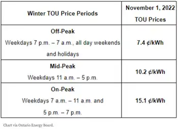
Electricity rates are about to change across Ontario
Ontario Electricity Rate Changes lower OEB Regulated Price Plan costs, adjust Time-of-Use winter hours and…
View more
Sign Up for Electricity Forum’s Newsletter
Stay informed with our FREE Newsletter — get the latest news, breakthrough technologies, and expert insights, delivered straight to your inbox.
Electricity Today T&D Magazine Subscribe for FREE
Stay informed with the latest T&D policies and technologies.
- Timely insights from industry experts
- Practical solutions T&D engineers
- Free access to every issue
