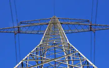
NC scientists testing immense power of the Gulf Stream off Hatteras

Gulf Stream currents may have more potential than offshore wind. Ocean currents move more slowly than wind but are about 800 times more dense, according to the Bureau of Ocean Energy Management. Water flowing at 12 miles per hour exerts the same force as a 110 mph wind.
"We know there is a vast resource out there," said Mike Muglia, a marine scientist with the Renewable Ocean Energy Program operated under the University of North Carolina Coastal Studies Institute in Wanchese. "The key is to find the sweet spot."
The Gulf Stream flows up the East Coast from the tip of Florida as winds push the ocean currents against the continental shelf, forcing them northward. Its currents run about 60 miles wide and 3,000 feet deep in places. The Gulf Stream passes about 15 miles offshore from Cape Hatteras, creating some of the best fishing conditions in the world.
The current off Hatteras runs about three times faster than if does off the Florida coast, Muglia said. The Gulf Stream transports nearly 4 billion cubic feet of water per second, more than all the world's rivers combined, according to the National Oceanographic and Atmospheric Administration.
One day, those currents could also be a key producer of alternative power, Muglia said.
"There is enough energy in the flow to power all of North Carolina and more," he said.
Producing power from Gulf Stream currents is at least 10 years away, he said. The question is whether it can be done in a cost-effective way. The cost of oil and the political will are also factors.
So far, no commercially connected turbines operatein the Gulf Stream, according to BOEM. A few prototypes have been tested off the coast of Florida. Challenges include turbine maintenance in a harsh, salty environment and long distances to run cable connections.
Muglia and his team collect data using three different methods, each with advantages and limitations.
One is a land-based radar system with units located in Duck, Buxton and Core Banks that measures currents every hour. The data is constant and long-term but gathers speeds down to only 6 feet below the surface. Another device, called an acoustic Doppler current profiler, gets deployed about 760 feet below the surface in the Gulf Stream and, using sonar technology, records currents above it. The disadvantage is that the measurements come from only one spot.
Finally, a Doppler current profiler fixed on a boom takes readings from a boat to about 100 meters deep as the crew crosses over the Gulf Stream. The instrument provides a good cross section of the stream, but trips off the coast are sporadic.
The Coastal Studies Institute is studying ocean energy potential from waves, tides and currents. The area that could have the most potential but toughest to conquer is the Gulf Stream.
"I believe we can do it," Muglia said.
Related News
Paying for electricity in India: Power theft can't be business as usual
NEW DELHI - India is among the world leaders in losing money to electricity theft. The country’s power sector also has a peculiar pattern of entities selling without getting the money on time, or nothing at all. Coal India is owed about Rs 12,300 crore by power generation companies, which themselves have not been paid over Rs 1 lakh crore by distribution companies. The figures of losses suffered by discoms are much higher. The circuit does get completed somehow, but the uneven transaction, which defies business sense, introduces a disruptive strand that limits the scope for any future planning. Regular…