Protective Relay Training - Basic
Our customized live online or in‑person group training can be delivered to your staff at your location.
- Live Online
- 12 hours Instructor-led
- Group Training Available
Regular Price:
$699
Coupon Price:
$599
Vancouver, BC
—
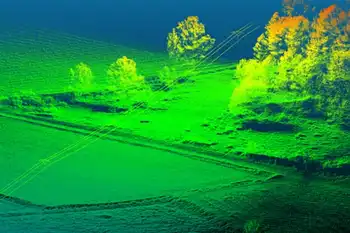
PhotoModeler UAS 2016 delivers drone photogrammetry with PPK, GPS camera calibration, 3D mapping, orthomosaics, NDVI and multispectral support, GIS coordinate systems, ground control points, and accurate stockpile volume measurement for surveying and agriculture.
What This Means
PhotoModeler UAS 2016 is drone photogrammetry software for 3D mapping, with PPK accuracy and multispectral NDVI support.
PPK workflow for post-processed GPS to achieve survey-grade accuracy
Full geographic coordinate system support for local projections
Volume objects enable accurate stockpile and mining volume calculations
Control point assist and multispectral/NDVI for advanced field ops
Vancouver, BC – Oct. 26, 2016 – New photogrammetry software optimized specifically for photographs taken with drones or unmanned aerial systems (UAS). The new PhotoModeler UAS 2016 software creates 3D models, measurements, and maps from photographs taken with ordinary cameras built-in or mounted on drones. It includes numerous features for optimized operation with drone photos including post processing kinematics (PPK), volume objects, full geographic coordinate systems support, multispectral image support and control point assist to support advanced situational awareness in field operations.
The new version of PhotoModeler is ideally suited for drone photogrammetry applications including surveying, ground contouring, surface model creation, stock pile volume measurement, mining and mine reclamation, environmental analysis, slope analysis, forensic analysis, construction, and agricultural crop analysis, as well as inspections that complement SCADA systems used by utilities. New applications for drone photogrammetry are developed monthly, including emergency response and winter storm preparedness across service territories. Eos PhotoModeler was introduced 23 years ago and has become one of the leading photogrammetric software platforms with a wide range of users in fields such as architecture, engineering, surveying, research, manufacturing and forensics.
PhotoModeler UAS 2016 software includes numerous features that provide higher performance in drone photogrammetry for workflows that integrate with advanced energy management systems in utility operations. Camera calibration is optimized for high accuracy with UASs and the global positioning system (GPS). Post processed kinematics (PPK) makes it possible to correct a survey with GPS data after the fact for survey grade accuracy. Volume objects provide easy and accurate volume data for stock piles and mining operations. Full geographic coordinate system support enables users to work in their local geographic coordinate system for better compatibility. Support is provided for multispectral images including Normalized Difference Vegetation Index (NDVI) surface models and ortho-mosaics for precision agriculture and rapid assessment after windstorm power outages in affected regions. An intuitive interface is provided for efficiently marking ground control points.
Related News
Related News
Sign Up for Electricity Forum’s Newsletter
Stay informed with our FREE Newsletter — get the latest news, breakthrough technologies, and expert insights, delivered straight to your inbox.
Electricity Today T&D Magazine Subscribe for FREE

Stay informed with the latest T&D policies and technologies.
- Timely insights from industry experts
- Practical solutions T&D engineers
- Free access to every issue