Aerial Utility Inspection for Power Grid Assessment
By Janet Henkai, PG&E and Anna Dillé, Cyberhawk
By Janet Henkai, PG&E and Anna Dillé, Cyberhawk

Aerial utility inspection is the process of evaluating transmission lines, distribution systems, substations, and vegetation corridors using helicopters, fixed wing aircraft, drones, LiDAR, and thermal imaging systems to assess asset condition, detect faults, and manage infrastructure risk across large electric power grid service territories. These inspections combine visual imaging, distance measurement, and thermal analysis to identify structural damage, clearance violations, and equipment deterioration that affect system reliability and safety.
For utility operations teams, aerial inspection solves a fundamental scale problem. Transmission corridors can extend hundreds of kilometers across mountainous terrain, forests, agricultural land, and urban environments where ground access is limited or inefficient.
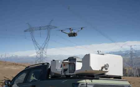
Helicopters, fixed wing aircraft, and unmanned aerial systems allow utilities to survey large portions of their service territory quickly while maintaining clear visual access to energized infrastructure. High resolution cameras, LiDAR sensors, and thermal imaging systems capture detailed data on conductors, insulators, hardware, and surrounding vegetation.
Aerial inspection programs rely on multiple aircraft platforms and sensing technologies to evaluate infrastructure under real operating conditions.
Helicopters are used for detailed patrols of transmission and distribution lines due to their maneuverability and ability to fly at low speeds along corridors. This allows inspectors to capture high-resolution images of insulators, connectors, and structural components.
Fixed wing aircraft are used for long-distance inspection programs covering extensive transmission networks. These aircraft enable rapid coverage of large service territories where hover capability is less critical.
Drones are typically deployed as targeted inspection tools after aerial patrols identify areas of concern. They provide close-range imaging of specific structures or components requiring further analysis.
Download our FREE Electrical Training Catalog and explore a full range of expert-led electrical training courses.

LiDAR systems generate precise three-dimensional measurements of conductor position and vegetation proximity. Thermal imaging detects abnormal heat signatures that indicate failing connections or overloaded components. Optical imaging captures visible defects such as broken hardware or structural deterioration.
Aerial inspection programs evaluate multiple classes of infrastructure during a single flight, allowing utilities to assess the full physical system rather than isolated components.
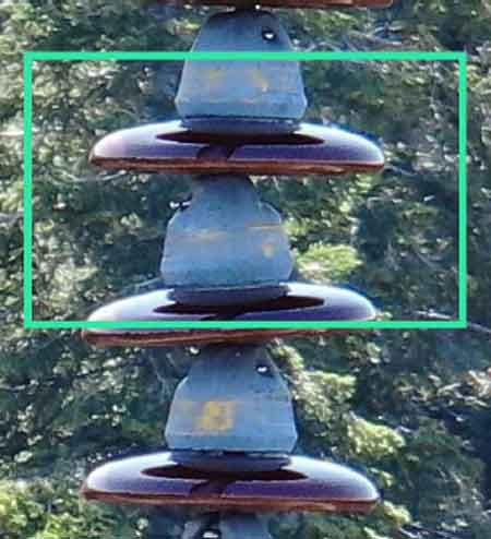
Transmission lines are inspected to confirm the condition of conductors, the integrity of insulators, the performance of structural hardware, and clearance from surrounding vegetation. Aerial views allow detection of defects such as damaged insulators, loose fittings, or excessive conductor sag.
Distribution systems are evaluated for pole condition, crossarm integrity, transformer performance, and vegetation encroachment. These inspections help identify localized risks that can lead to feeder outages.
Substations are included in aerial inspection routes to detect contamination, oil leaks, damaged insulators, and structural issues requiring further investigation.
Vegetation corridors are a primary focus. Aerial inspection identifies encroachment risks before vegetation contact occurs, reducing the likelihood of faults during wind, storm, or wildfire conditions.
Aerial inspection systems do more than capture images. They identify specific failure conditions that directly impact grid performance.
Visual imaging detects broken insulators, cracked components, missing hardware, and structural deformation.
Thermal imaging identifies hotspots caused by high resistance connections, overloaded conductors, or deteriorating equipment.
LiDAR detects clearance violations between conductors and vegetation, enabling utilities to prevent contact faults.
Corona and ultraviolet imaging can reveal electrical discharge conditions that indicate insulation degradation.
These detection capabilities allow utilities to identify issues early and prioritize corrective action before failure occurs.
Aerial inspection delivers value through clear cause-and-effect relationships in engineering.
LiDAR measurement identifies vegetation encroachment, which reduces conductor clearance and increases the probability of contact faults. Early detection allows vegetation management before outages occur.
Thermal imaging detects abnormal heat signatures at connectors or splices, indicating increased resistance. If left uncorrected, these conditions lead to equipment failure or conductor damage.
Visual inspection identifies structural defects such as cracked insulators or loose hardware. These conditions increase the likelihood of mechanical failure under load or weather stress.
Aerial patrol coverage enables utilities to quickly detect issues across large geographic areas, reducing inspection cycle time and improving system reliability by accelerating maintenance response.
Aerial inspection programs are designed to operate at the transmission corridor and service territory scale.
Utilities may manage thousands of kilometers of transmission and distribution infrastructure. Ground inspection at this scale requires significant labor, extended timelines, and difficult access conditions.
Aircraft-based inspection allows utilities to evaluate large areas in a fraction of the time while maintaining consistent inspection quality. Scheduled aerial patrol cycles ensure that infrastructure is reviewed regularly and that emerging risks are identified before they escalate.
Data collected during aerial inspections can also support broader system analysis and condition monitoring programs such as Power Line Monitoring System.
Aerial utility inspection is critical following extreme weather events.
Storms, wildfires, ice accumulation, and high winds can damage structures, topple poles, and create conditions for vegetation contact. Ground access is often limited due to debris, flooding, or terrain.
Aircraft enable rapid assessment of affected areas, allowing utilities to identify damaged infrastructure and prioritize restoration efforts. Aerial surveys provide immediate visibility into system conditions, improving outage response and crew deployment efficiency.
Think you know Vision AI, Inspection & Field Intelligence? Take our quick, interactive quiz and test your knowledge in minutes.
Aerial inspection and monitoring systems serve different operational roles.
Aerial inspection provides a periodic, visual evaluation of infrastructure condition. It identifies physical defects such as structural damage, vegetation encroachment, and equipment deterioration.
Monitoring systems provide continuous operational data. Platforms such as Power Grid Monitoring Systems detect electrical behavior, including voltage variations, load conditions, and fault activity.
This distinction is essential. Inspection identifies physical risk conditions, while monitoring identifies electrical performance issues. Together, they provide a complete picture of grid health.
Aerial inspection findings directly support maintenance planning and asset management.
Inspection data is used to prioritize repairs, schedule vegetation management, and plan infrastructure upgrades. Utilities integrate aerial inspection results into programs such as Drone Utility Inspection, where targeted follow-up inspections confirm defects.
For conductor-focused inspections, utilities may deploy specialized programs such as Drone Power Line Inspection.
Aerial inspection also supports condition-based strategies such as Predictive Maintenance for Utilities, where identified defects are tracked and addressed before failure occurs.
For transmission-specific aerial patrols focused on corridor-scale inspection, utilities implement programs such as Aerial Power Line Inspection.
For utility operators, aerial inspection findings determine whether a condition can be scheduled for routine maintenance or requires immediate field repair before equipment failure, exposure to outages, or wildfire risk increases.
Advantages To Instructor-Led Training – Instructor-Led Course, Customized Training, Multiple Locations, Economical, CEU Credits, Course Discounts.
Request For QuotationWhether you would prefer Live Online or In-Person instruction, our electrical training courses can be tailored to meet your company's specific requirements and delivered to your employees in one location or at various locations.