AI Wildfire Detection for Power Line Fire Risk
By Andy Abranches, PG&E
By Andy Abranches, PG&E

AI wildfire detection uses camera networks, thermal imaging, satellite data, and weather sensors to identify smoke, heat, and ignition risk near power lines, helping utilities reduce wildfire exposure, speed dispatch, and protect grid reliability.
Artificial intelligence wildfire detection uses computer vision, thermal sensing, environmental telemetry, and geospatial analytics to identify wildfire ignition risk near utility assets before a small event becomes a system emergency.
For utilities, the challenge is recognizing smoke, heat, or abnormal conditions near transmission corridors and distribution rights of way fast enough to support a field decision. In high risk terrain, delayed confirmation can turn a local ignition into an outage event, a public safety emergency, or a fast moving vegetation fire.
This page has a different job than the rest of the cluster. Inspection pages examine asset condition at intervals. Monitoring pages track electrical behavior continuously. AI wildfire detection focuses on the environment around electrical infrastructure, using visual, thermal, weather, and satellite inputs to detect ignition indicators and support rapid response.
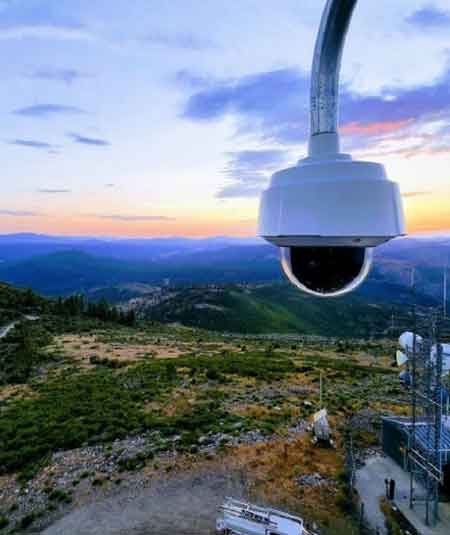
Most utility systems start with cameras installed on towers, ridges, substations, or other elevated sites with wide views of vegetation corridors, dry fuel conditions, and power line rights of way where ignition risk from electrical infrastructure is highest. Computer vision models review the image stream for early smoke signatures, plume movement, color changes, and scene behavior that differ from cloud shadows, dust, or haze. Thermal sensors add another layer by identifying heat anomalies that may appear before flames are visible in standard video.
AI wildfire detection systems analyze multiple data streams simultaneously to recognize early wildfire indicators. Camera networks detect smoke patterns using computer vision, thermal sensors identify abnormal heat signatures, environmental sensors monitor wind, humidity, and temperature, and satellite systems detect regional fire hotspots. Analytics platforms combine these inputs to estimate ignition location, verify the event, and alert utility operators so field crews can respond before a small ignition develops into a large vegetation fire.
Stay informed with our FREE Vision AI, Inspection & Field Intelligence Newsletter — get the latest news, breakthrough technologies, and expert insights, delivered straight to your inbox.
Computer vision models review the image stream for early smoke signatures, plume movement, color changes, and scene behavior that differ from cloud shadows, dust, or haze.
The system must do more than detect. It must estimate location, confidence, and whether the event is close enough to utility infrastructure to justify action. That is why wildfire platforms combine image analytics with data on wind, humidity, ambient temperature, and fuel conditions.
This environmental role is different from Drone Utility Inspection, which documents asset condition during planned field review. It is also different from Drone Power Line Inspection, where the focus is on conductor, hardware, or structure condition rather than on active ignition evidence.
Utilities separate wildfire detection from visual inspection because the cadence and triggers differ. Aerial Utility Inspection and Aerial Power Line Inspection help crews assess poles, conductors, insulators, and vegetation exposure across a route, but they do not provide continuous smoke surveillance during the operating day.
The page must also remain separate from electrical visibility topics. Power Grid Monitoring Systems and Power Line Monitoring System watch current, voltage, loading, conductor temperature, and other grid conditions. Wildfire detection watches the surrounding fire environment.
That separation matters in operations. A feeder can look electrically normal while smoke begins outside the substation view. A camera system may confirm a plume before SCADA indicates any abnormality. In the opposite case, a fault signature may appear first and trigger review of image feeds, weather exposure, and patrol priorities.
From an OT perspective, the value of AI wildfire detection is response compression. A useful platform reduces the time between ignition cue, operator awareness, location confirmation, and dispatch decision. The workflow usually moves through four gates: detect, validate, geolocate, and escalate.
Utilities, therefore, connect wildfire cameras, thermal sensors, satellite wildfire monitoring, and weather stations into a common operating view. Many platforms integrate GOES satellite data and fire hotspot detection algorithms to provide wide area monitoring beyond the line of sight of camera networks. Some organizations also correlate the fire signal with Electrical Fault Detection so operators can determine whether an electrical event may have preceded the smoke report.
Dust, marine layers, agricultural burning, and low sun angle can all mimic smoke. Satellite products expand coverage, but they may have lower temporal resolution than local camera feeds. Thermal devices improve night-time visibility, but they can still trigger nuisance alarms due to hot surfaces or reflected energy. If the utility sets the detection threshold too high, it misses early ignitions. If it sets the threshold too low, operators drown in false positives.
Coverage geometry is one constraint. Cameras need a line of sight, and mountainous terrain creates blind areas that can hide a low smoke column until it grows. Communications are another constraint because a remote camera site is only useful if imagery, alarms, and device health return reliably to the operating center.
The tradeoff is coverage cost versus confirmation speed. More cameras, more weather stations, and better communications improve visibility, but they also increase data volume, maintenance burden, and model management complexity. Utilities with broad rural territory usually prioritize high fire risk zones first, then expand based on ignition history, conductor exposure, terrain, and dispatch times.
Utilities use AI wildfire detection because the goal is not simply to observe fires. It is to interrupt the wildfire sequence early enough that operators, field crews, and emergency partners still have time to act. When smoke is identified within minutes near power infrastructure, the utility gains decision time, and in wildfire operations, decision time is often the difference between local containment and large-scale escalation.
Download our FREE Electrical Training Catalog and explore a full range of expert-led electrical training courses.

Advantages To Instructor-Led Training – Instructor-Led Course, Customized Training, Multiple Locations, Economical, CEU Credits, Course Discounts.
Request For QuotationWhether you would prefer Live Online or In-Person instruction, our electrical training courses can be tailored to meet your company's specific requirements and delivered to your employees in one location or at various locations.